TouchScreenTravels logo

TouchScreenTravels

Our Touch, your Travels…

This is a preview of the full content of our Grand Canyon & Flagstaff app.

Please consider downloading this app to support small independent publishing and because:

  • All content is designed for mobile devices and works best there.
  • Detailed in-app maps will help you find sites using your device’s GPS.
  • The app works offline (one time upgrade required on Android versions).

The app will also allow you to:

  • Add custom locations to the app map (your hotel…).
  • Create your own list of favourites as you browse.
  • Search the entire contents using a fast and simple text-search tool.
  • Make one-click phone calls (on phones).
iOS App Store Google Play

Cape Royal

270-degree view of the canyon

Stand at the tip of the Walhalla Plateau and you’re surrounded by 270 degrees of spectacular canyon formations. The 15-mile drive to get there winds through pine forest past Vista Encantada, Roosevelt Point (10-minute walk), and Walhalla Ruins (rock foundations of two Ancient Puebloan houses) to reach the majestic scene.

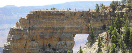
A paved, .3-mile path leads to the view of the river a mile below and six miles away. A short side trail drops below the viewpoint to Angels Window, a natural arch in the limestone caprock. The nearby Cliff Springs Trail, 1-mile roundtrip, leads through a forested ravine to a flowing spring.

Practical Info Practical Info icon

www.nps.gov

Hours: Seasonal May 15-Oct. 15

Cape Royal Road

Sunrise & Sunset

Text © George Miller

Image by Photo by bloodredrapture