TouchScreenTravels logo

TouchScreenTravels

Our Touch, your Travels…

This is a preview of the full content of our Grand Canyon & Flagstaff app.

Please consider downloading this app to support small independent publishing and because:

  • All content is designed for mobile devices and works best there.
  • Detailed in-app maps will help you find sites using your device’s GPS.
  • The app works offline (one time upgrade required on Android versions).

The app will also allow you to:

  • Add custom locations to the app map (your hotel…).
  • Create your own list of favourites as you browse.
  • Search the entire contents using a fast and simple text-search tool.
  • Make one-click phone calls (on phones).
iOS App Store Google Play

Walhalla Overlook and Ruins

If walls could talk

Near the end of the Cape Royal “sky island” peninsula which juts out over the canyon, the view from Walhalla Overlook encompasses the Unkar Delta of the Colorado River to the southeast and the Walhalla Plateau to the northwest.

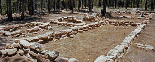
Paleo-Indians lived in both areas from the hunter and gather period 10,000 years ago to the period of farming, basket weaving, and pottery making 1,000 years ago. Archeologists have excavated a 30 room pueblo on the Unkar Delta and have unearthed a 6-room pueblo in the Walhalla Glades near the overlook.

From 1050 to 1150 AD, people farmed the delta, rim, and plateaus for corn, squash, beans. Catch the ranger program “Into the Past” to learn more about the first humans to gaze in wonder at the canyon. A short path leads to the ruins, foundation stones of the ancient stone houses.

Practical Info Practical Info icon

www.nps.gov

Price: free

Hours: May 15—Oct. 15

Cape Royal Road

History

The North Rim In-A-Day

Text © George Miller

Image by Photo by Public Domain