TouchScreenTravels logo

TouchScreenTravels

Our Touch, your Travels…

This is a preview of the full content of our Grand Canyon & Flagstaff app.

Please consider downloading this app to support small independent publishing and because:

  • All content is designed for mobile devices and works best there.
  • Detailed in-app maps will help you find sites using your device’s GPS.
  • The app works offline (one time upgrade required on Android versions).

The app will also allow you to:

  • Add custom locations to the app map (your hotel…).
  • Create your own list of favourites as you browse.
  • Search the entire contents using a fast and simple text-search tool.
  • Make one-click phone calls (on phones).
iOS App Store Google Play

Maricopa Point

Sublime view

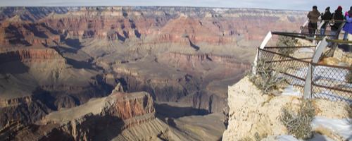
Looking towards the North Rim and eastward up the Canyon, the splendor of the eroded buttes and peaks of the formations is almost too much for the human mind to grasp. The scalloped Redwall cliffs and sculpted ridge below the viewpoint attest to the creative force of erosion over millions of years.

The arid plateau and harsh winters stunt tree growth as well as fracture the rock cliffs. The grizzled pines and juniper trees on the rim could be hundreds of years old. Maricopa Point east to Trailview Overlook: .7 mile Maricopa Point west to Powell Point: .5 mile

Practical Info Practical Info icon

www.nps.gov

Hermit Road

South Rim: Hermit Road In-A-Day

Gaze into space

Text © George Miller

Image by Photo by George Miller