TouchScreenTravels logo

TouchScreenTravels

Our Touch, your Travels…

This is a preview of the full content of our Grand Canyon & Flagstaff app.

Please consider downloading this app to support small independent publishing and because:

  • All content is designed for mobile devices and works best there.
  • Detailed in-app maps will help you find sites using your device’s GPS.
  • The app works offline (one time upgrade required on Android versions).

The app will also allow you to:

  • Add custom locations to the app map (your hotel…).
  • Create your own list of favourites as you browse.
  • Search the entire contents using a fast and simple text-search tool.
  • Make one-click phone calls (on phones).
iOS App Store Google Play

Monument Creek Vista

Roadside vista

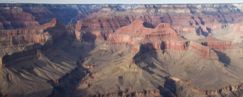
Look down from this roadside viewpoint deep into the canyon and glimpse of the river. Monument Creek carves the rock strata from the rim through the Tonto Platform and slices into the 2-billion basaltic rock of the Inner Gorge. A knife-like ridge stands in the foreground and sweeping red-rock buttes march toward the North Rim.

From this shuttle stop to Hermits Rest, the Rim Trail becomes paved and called the Hermit Road Greenway Trail with bicycles allowed. Much of the Greenway Trail westward is through the forest away from the rim, so rim hikers often take the shuttle for the next 1.7 miles to Pima Point. Monument Creek Vista east to the Abyss: .9 mile Monument Creek Vista west to Pima Point: 1.7 miles

Practical Info Practical Info icon

www.nps.gov

Hermit Road

South Rim: Hermit Road In-A-Day

Gaze into space

Text © George Miller

Image by Photo by George Miller