TouchScreenTravels logo

TouchScreenTravels

Our Touch, your Travels…

This is a preview of the full content of our Grand Canyon & Flagstaff app.

Please consider downloading this app to support small independent publishing and because:

  • All content is designed for mobile devices and works best there.
  • Detailed in-app maps will help you find sites using your device’s GPS.
  • The app works offline (one time upgrade required on Android versions).

The app will also allow you to:

  • Add custom locations to the app map (your hotel…).
  • Create your own list of favourites as you browse.
  • Search the entire contents using a fast and simple text-search tool.
  • Make one-click phone calls (on phones).
iOS App Store Google Play

Mohave Point

Which way to look?

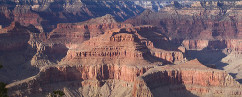
This expansive view of the canyon spreads from a sheer red-rock ridge that curves across the canyon below the point, great for blazing sunset colors, to the cross-canyon buttes and spires, and then to the sinuous ribbon of water flowing west. At sunset, the sheer cliff of the upper viewpoint morphs from yellowish limestone to fiery hues of red.

Hikers often opt to catch the shuttle for the 2 miles to Monument Creek Vista and skip the Abyss, though the trailside views along the way are as spectacular as any. The return shuttle bus only stops at Mohave and Hopi points to take hikers back to the Village. Mohave Point east to Hopi Point: .8 mile Mohave Point west to the Abyss: 1.1 mile Mohave Point west to Monument Creek Vista: 2.5 miles

Practical Info Practical Info icon

www.nps.gov

Price: free

Hermit Road

South Rim: Hermit Road In-A-Day

Gaze into space

Text © George Miller

Image by Photo by George Miller