TouchScreenTravels logo

TouchScreenTravels

Our Touch, your Travels…

This is a preview of the full content of our Grand Canyon & Flagstaff app.

Please consider downloading this app to support small independent publishing and because:

  • All content is designed for mobile devices and works best there.
  • Detailed in-app maps will help you find sites using your device’s GPS.
  • The app works offline (one time upgrade required on Android versions).

The app will also allow you to:

  • Add custom locations to the app map (your hotel…).
  • Create your own list of favourites as you browse.
  • Search the entire contents using a fast and simple text-search tool.
  • Make one-click phone calls (on phones).
iOS App Store Google Play

Cape Final Trail

Flat trail, wide-angle canyon view

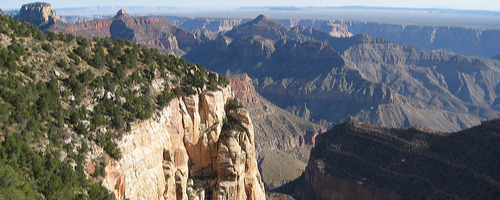
If you only do one short cross-country hike, try this easy 4-mile roundtrip. Hike through open pine forest on an old roadbed, get a glimpse of the inner canyon, then reach Cape Final and spin around for a clear, 270-degree view. Across the chasm, colorful temples, buttes, cliffs, and ridges lead to the river, then the South Rim rises almost vertically. The trail begins 2.5 miles before the end of the Cape Royal road.

Practical Info Practical Info icon

www.nps.gov

Hours: Seasonal May 15-Oct. 15

Cape Royal Road

North Rim Hikes

Text © George Miller

Image by Photo by brewbooks