TouchScreenTravels logo

TouchScreenTravels

Our Touch, your Travels…

This is a preview of the full content of our Grand Canyon & Flagstaff app.

Please consider downloading this app to support small independent publishing and because:

  • All content is designed for mobile devices and works best there.
  • Detailed in-app maps will help you find sites using your device’s GPS.
  • The app works offline (one time upgrade required on Android versions).

The app will also allow you to:

  • Add custom locations to the app map (your hotel…).
  • Create your own list of favourites as you browse.
  • Search the entire contents using a fast and simple text-search tool.
  • Make one-click phone calls (on phones).
iOS App Store Google Play

Bright Angel Point

End of the road viewpoint

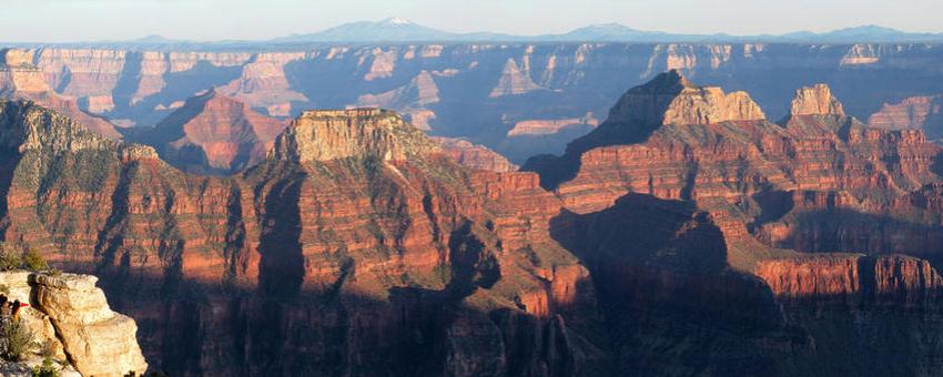
When you can’t drive any farther, get out and walk 1/2 mile to the tip of the cliff. Behold, the Grand Canyon in all its glory. Hundreds of multi-hued peaks, ridges, and spires fill the gorge. Across the abyss, the South Rim glows on the horizon and San Francisco Peaks dots the horizon. Listen and you can hear Roaring Springs far below.

The paved trail begins at the Grand Canyon Lodge or the log shelter in the parking lot. Grab a nature trail guide from the box at the start and learn something new. Download a PDF map of the North Rim viewpoints and trails.

Practical Info Practical Info icon

North Rim day hikes

Open: Seasonal May 15-Oct. 15

The Kaibab Plateau

Sunrise & Sunset

The North Rim In-A-Day

Text © George Miller

Image by Photo by Grand Canyon NPS