North Kaibab Trail
Forget the StairMaster
Sometimes less is better
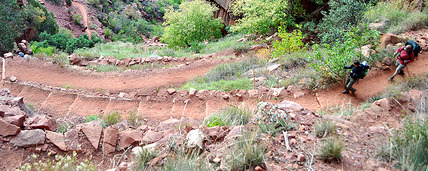
Generally, the trail descends steeply with numerous switchbacks. Shorter hikes down (and up) the grade give you a canyon experience impossible to duplicate from the rim.
Try Coconino Overlook (1.5 miles roundtrip, 800 ft. drop), Supai Tunnel (4 miles roundtrip, 1,450 ft. drop), Roaring Springs (9.4 miles roundtrip, 7–8 hrs., 3,050 ft. drop), or backpack to Cottonwood Campground (7 miles one-way, 4,179 ft. drop).
Don’t even think about day hiking beyond Roaring Springs, 3,050 feet below the rim. Other’s have tried and many have died.
Getting there
The Hikers Shuttle picks up daily at the Lodge at 5:45 a.m. and 7:10 a.m. Sign up at the Lodge 24 hours ahead. At the trailhead (8,250 ft. elev.), you’re one mile from the river, if you could fly. Or 14.2 miles to Phantom Ranch (2,546 ft. elev.). Water available at Supai Tunnel (1.7 mi., 6,800 ft. elev.), Roaring Springs (4.7 mi., 5,200 ft. elev.), Pumphouse Residence (5.4 mi.), Cottonwood Campground (6.8 mi., 4,080 ft. elev.), and Bright Angel Campground (14 mi., 2,546 ft. elev.).