TouchScreenTravels logo

TouchScreenTravels

Our Touch, your Travels…

This is a preview of the full content of our Barbados’ Best app.

Please consider downloading this app to support small independent publishing and because:

  • All content is designed for mobile devices and works best there.
  • Detailed in-app maps will help you find sites using your device’s GPS.
  • The app works offline (one time upgrade required on Android versions).
  • All advertising (only present on Android versions) can be removed.

The app will also allow you to:

  • Add custom locations to the app map (your hotel…).
  • Create your own list of favourites as you browse.
  • Search the entire contents using a fast and simple text-search tool.
  • Make one-click phone calls (on phones).
iOS App Store Google Play

THE ISLAND

Pear-shaped Barbados is only 21 miles (34km) long and 14 miles (23km) across at its widest point. What’s more, the country is generally less mountainous than its Caribbean neighbours, so altogether much easier to explore. It can easily be divided into six areas, as indicated on the map.

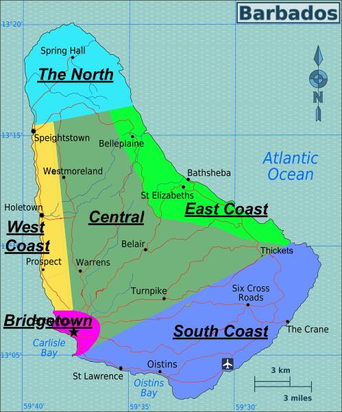
Bridgetown & West Coast

The capital Bridgetown, home to over a third of the country’s 288,000 population, sprawls round delightfully sheltered Carlisle Bay, on the southwest coast. Heading north out of the city, the main road takes you along the famous West Coast, renowned for its glorious beaches, sheltered coves, chic restaurants and some of the island’s swankiest hotels and private villas. The country’s oldest settlement, Holetown, and second ‘city’, Speightstown, are also located here.

The North & East Coast

Read the full content in the app
iOS App Store Google Play

Bridgetown

Central

East Coast

The North

South Coast

West Coast

Text © Sara Humphreys

Image by C Williams & OSM