TouchScreenTravels logo

TouchScreenTravels

Our Touch, your Travels…

This is a preview of the full content of our Peru’s Best app.

Please consider downloading this app to support small independent publishing and because:

  • All content is designed for mobile devices and works best there.
  • Detailed in-app maps will help you find sites using your device’s GPS.
  • The app works offline (one time upgrade required on Android versions).
  • All advertising (only present on Android versions) can be removed.

The app will also allow you to:

  • Add custom locations to the app map (your hotel…).
  • Create your own list of favourites as you browse.
  • Search the entire contents using a fast and simple text-search tool.
  • Make one-click phone calls (on phones).
iOS App Store Google Play

Cójup Trek

Quillcayhuanca–Cójup (3 days)

Cojup

This 3 day trek is one of the easier routes, compared to others in Huascarán National Park. The trail is 32km (20 miles) and the altitude is between 3090-5050 m (10,138-16,568ft).
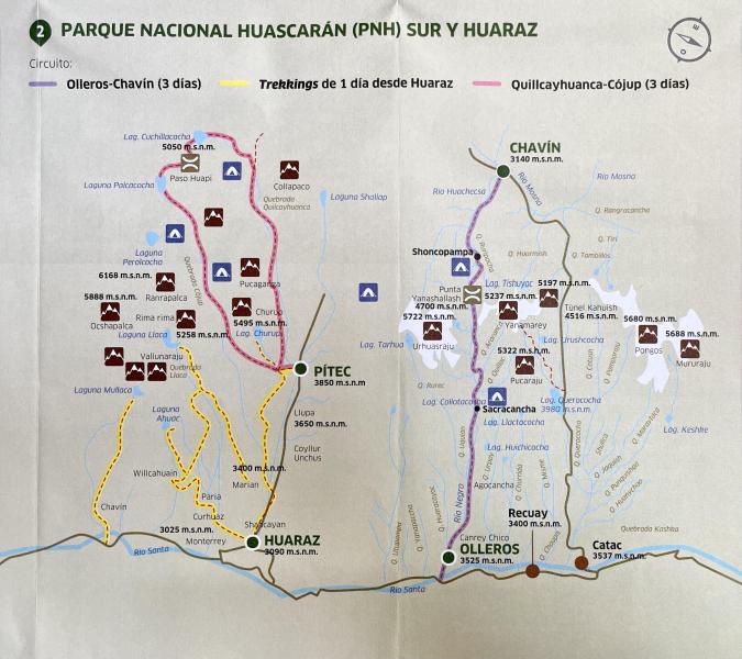
Cojup Trek Map

The lakes you’ll go by are Tullpacocha, Cuchillacocha and Palcacocha. The highest pass you go over is Huapi at 5050m (16,568ft). From the pass you can see five peaks over 6000m, including Palcaraju (pictured above) and two more over 5000m.

Practicalities

You can take a colectivo to Pitec, which only takes about half an hour. Colectivos depart from a red house on the corner of Avenida Agustín Gamarra and Avenida Las Americas, across from the Servicentro Huaraz gas station. In July, 2022 the price was s/20 for roundtrip to Pitec.

Churup Colectivo Paradero

The first colectivo departs Huaraz at 7am and the last one leaves Pitec at 5pm. They give you a receipt when you pay in Huaraz and collect it when you get back in the van in Pitec. If you’re later than 5pm they might notice and wait for you, but don’t count on it.

Cordillera Blanca Treks

Text © Heather Jasper

Images by Free Map Distributed by iPeru, Heather Jasper