TouchScreenTravels logo

TouchScreenTravels

Our Touch, your Travels…

This is a preview of the full content of our Grand Canyon & Flagstaff app.

Please consider downloading this app to support small independent publishing and because:

  • All content is designed for mobile devices and works best there.
  • Detailed in-app maps will help you find sites using your device’s GPS.
  • The app works offline (one time upgrade required on Android versions).

The app will also allow you to:

  • Add custom locations to the app map (your hotel…).
  • Create your own list of favourites as you browse.
  • Search the entire contents using a fast and simple text-search tool.
  • Make one-click phone calls (on phones).
iOS App Store Google Play

Grandview Trail

Rugged hikes

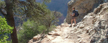
Great views but you pay the price. This steep, unmaintained trail without shade or water can knock you flat in the summer when temps exceed 100 F. For day hikes, the trail drops 1,165 feet in 1 mile to the Coconino Saddle.

The trail to Horseshoe Mesa, built by copper miners in 1892 to reach mines on the Mesa, descends 2,600-ft. in 3 miles. The Tonto Trail Junction is 6.8 miles and the river 13 miles and a 4,800 feet descent.

Hiking the trail is not advised in the summer. Take these warnings seriously. Over 250 people require emergency rescue each year. The trailhead begins at Grandview Viewpoint on Desert View Drive. Download a PDF of the trail map.

Practical Info Practical Info icon

www.nps.gov

Desert View Drive

South Rim Hikes

Text © George Miller

Image by Photo by Peter Stevens