TouchScreenTravels logo

TouchScreenTravels

Our Touch, your Travels…

This is a preview of the full content of our Banff & Canada’s Rockies app.

Please consider downloading this app to support small independent publishing and because:

  • All content is designed for mobile devices and works best there.
  • Detailed in-app maps will help you find sites using your device’s GPS.
  • The app works offline (one time upgrade required on Android versions).
  • All advertising (only present on Android versions) can be removed.

The app will also allow you to:

  • Add custom locations to the app map (your hotel…).
  • Create your own list of favourites as you browse.
  • Search the entire contents using a fast and simple text-search tool.
  • Make one-click phone calls (on phones).
iOS App Store Google Play

Barrier Lake Info Centre

Advice for Kananaskis activities

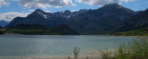
Only 8km from the main entry point to Kananaskis Country on Hwy-1, this is the best place to run through any plans before you strike out: closures, avalanche risks and bear sightings in particular.

Pick up details too of the hiking and mountain bike trails that begin just south of the centre beside the Barrier Lake Dam.

The centre has a Friends of Kananaskis Country bookstore selling guidebooks and maps.

The Alberta Parks website has a useful array of free downloadable maps.

Practical Info Practical Info icon

Daily Apr–Oct 8am—6pm; rest of year 9am—4pm

albertaparks.ca/barrier-lake-info/

Information

Kananaskis Country

Text © Christian Williams

Image by